
By SERGEY KADINSKY
Forgotten New York correspondent
At the corner of Essex and Delancey Streets is a glass tower with signs for The Market Line, an underground food and retail complex that is the latest version of the Essex Market that has hosted small businesses on the Lower East Side for more than two centuries. Not knowing much about this post-millennial development, its name sounds like a transit line and ironically next to the subterranean shops is an abandoned trolley terminal.
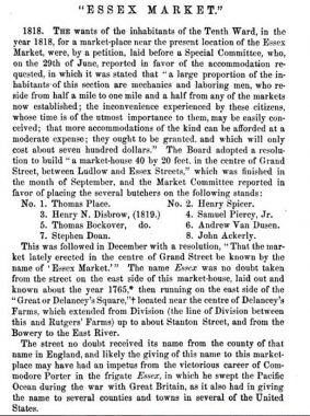
The name “Essex Market” has been in use since 1818 at the earliest.
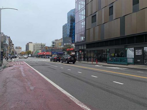
The Market Line opened in 2019 with 30 vendors as part of a $1.9 billion development of a long-dormant urban renewal area, the largest in Manhattan at the time. The postmodern exterior is a blend of glass, metal, and brick panels in shades of brown, an understated presence for a high-rise with an ambitious basement space. Although its anchor building abuts the Delancey-Essex subway station, there is no direct connection between The Market Line and the station. The inspiration for its name is its design, as a linear public space that stretches for three blocks beneath the new towers.
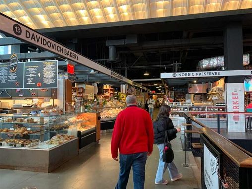
Beer, books, international food, under canopies of hanging lights, exposed pipes and ducts that gives this new space an industrial look that falls short of Chelsea Market’s authenticity but earns points for filtering in natural light and high ceilings for the spacious feel. The logo of The Market Line is a polygon of the neighborhood’s borders but I still thought of transit as its name reminded me of the Market-Frankford Line in Philadelphia, and that city’s Reading Terminal Market. The scene here is also reminiscent of Turnstyle, that row of shops in the Columbus Circle station mezzanine.
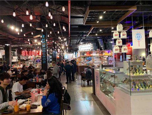
As Forgotten-NY documents places that are gone or soon-to-be-gone, across the street is the second version of Essex Market, completed in 1940 during the administration of Mayor LaGuardia who fought to get pushcart vendors off the crowded streets. Most of its initial vendors were Jewish and Italian immigrants. As the neighborhood demographics changed, the flavor became more Puerto Rican and Chinese. The market’s third version across the street has its most diverse collection of food vendors in a scene that was described by the New York Times architecture critic as the “anti-Hudson Yards,” noting the community input, upper and lower income units in one tower, and working-class character in contrast to the upscale development on the west side of Midtown.
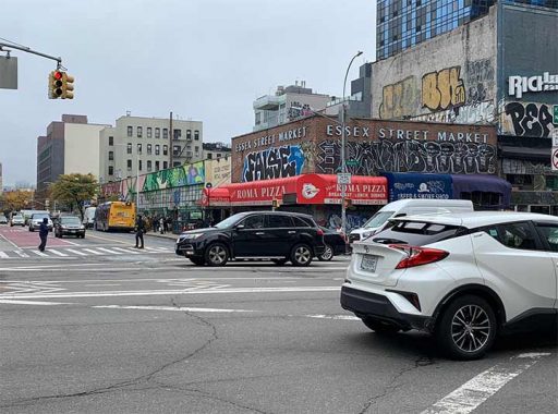
At its corner of Essex and Delancey, the initial tenant was Levy’s Frankfurters, which was succeeded by New Roma Pizza. Its late hours gave it plenty of business from youths returning from a night of partying before they headed for the subway ride back to the outer boroughs. In 2016, the market was beautified with murals on its exterior and interior, colorful patterns and tropical scenery by Gera Lozano that gave passersby on this architecturally uninspiring block a reason to pause, admire, and go inside. On the illegal side of art, I’m impressed by the FALSE tagger. How did this vandal get there and how long did it take to complete such a tag, and how did this person avoid arrest at such a heavily trafficked intersection?
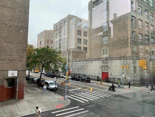
A block to the south of Delancey Street is the massive Seward Park High School, which officially closed in 2016 and was revamped with five smaller high schools sharing space. But to everyone, the building will always be known by its old name, and memories of numerous famous alumni: actors such as Tony Curtis, Zero Mostel, and Luis Guzman; baseball stars Edwin Almonte and Roberto Duran, among other boldface names. Its schoolyard is on the rooftop, which has its own collection of murals.
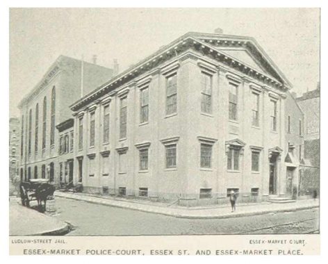
This building was completed in 1929 on the site of the Ludlow Street Jail and the first version of Essex Market, which opened on this block in 1818. Thomas Farrington De Voe wrote the book on the city’s first public markets in 1862, noting the namesake of Essex Market and its street. The old jail and market were separated by a short street, Essex Market Place, which was demapped in favor of the high school. The jail resembled a castle while the first Essex Market had the pediment roof of the Greek-inspired federal style.

The NYCHA Seward Park Extension tower is a work of brutalism in contrast to the human-scale tenements and its courtyard matches the tower with more concrete and bricks rather than vegetation.
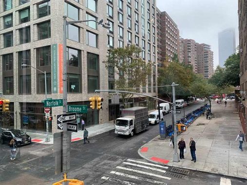
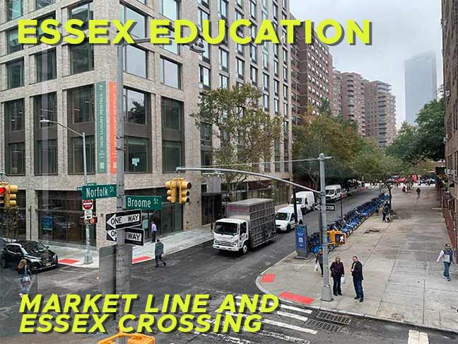
On the southeast corner of Broome and Norfolk streets is a new luxury rental building, The Suffolk, which stands on the site of Beth Hamedrash Hagadol, a landmarked historic church-turned synagogue that went down in flames in 2017. At that time, it was vacant for more than a decade due to the lack of congregants. At its peak of popularity in the late 19th century, its pulpit hosted Rabbi Jacob Joseph, the city’s first and only Orthodox Chief Rabbi. The title was retired after his death because the Jewish community could not agree on a successor. Following the arson, the Landmarks Preservation Commission delisted the building and issued recommendations to salvage some of its artifacts. Such a precedent can be found in Brooklyn, where artifacts and photos of Our Lady of Loreto appear in the apartment building that replaced it.
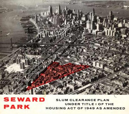
Across the street from Seward Park High School is its namesake park and the co-op complex that shares its name. Completed in 1959, it stands atop more than a dozen demapped blocks where tenements were knocked down in favor of these towers-in-a-park. The “slum clearance” report from 1955 shows the footprint of the Seward Park Co-op and it wasn’t the first superblock on the Lower East Side. By then, labor-sponsored Amalgamated Dwellings and Hillman Housing, along with NYCHA’s Vladeck, LaGuardia, Alfred E. Smith, Baruch, Wald, and Riss Houses, served as precedent for this development.
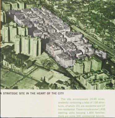
Following the completion of the Seward Park Co-op, the city then set its sights on 19 acres of tenements between Grand and Delancey streets, designating the condemned blocks as SPURA- Seward Park Urban Renewal Area. The high school appears on the top left of this aerial photo.
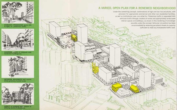
In this illustration of the city’s plan, I highlighted three religious buildings spared from the wrecking crews, Saint Mary’s Roman Catholic Church, Beth Hamedrash Hagadol synagogue, and the Bialystoker Synagogue, along with The Neighborhood Playhouse. Of particular interest on this rendering is the Lower Manhattan Expressway (Lomex) that would have sliced through the Lower East Side and SoHo, carrying Interstate 78 between the Holland Tunnel and Williamsburg Bridge.

A map of the proposed urban renewal project shows concrete superblocks with parkland bordering on the curve where Delancey Street becomes the Lomex. Very typical of Robert Moses to put a green space next to a highway. Among the items here that became reality was the new 7th Precinct at Pitt Street, which was completed in 1973. The NYPD shares this building with FDNY Engine 15 Ladder 18 in a facility nicknamed Fort Pitt. This precinct has a long history, having worked in three buildings since its founding in 1848.
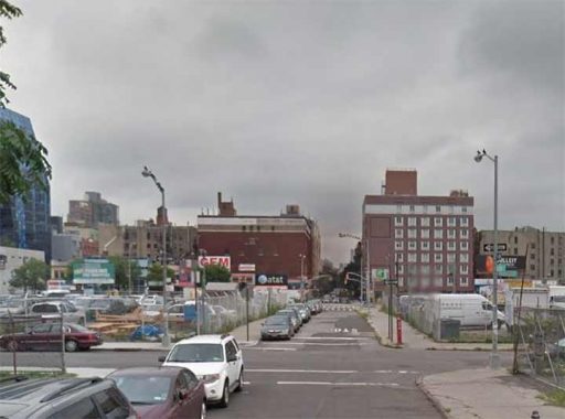
But in contrast to previous slum clearance campaigns, SPURA stalled amid political infighting. The tenements came down but the blocks stood empty for nearly 40 years. A 2013 Google Street View looking north on Suffolk and Broome streets shows massive parking lots on the SPURA footprint following the cancellation of Lomex and failure to build housing here. The red building without windows in the background is the former Loew’s Delancey theater, which screened its last film in 1976. For most New Yorkers, Broome Street is better known as the feeder road to the Holland Tunnel in SoHo. To the east of the Bowery it is a quiet street that runs in segments broken up by parks and housing superblocks.
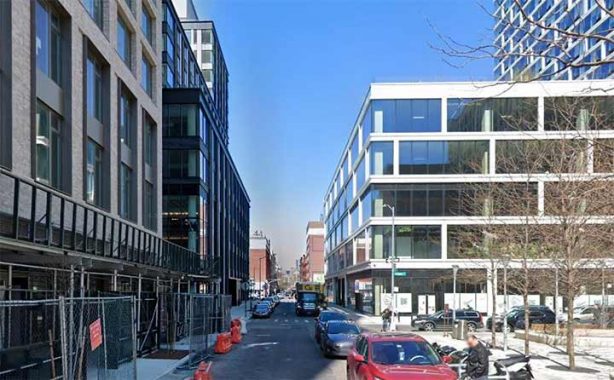
In the third decade of this millennium, this corner has been developed entirely. Conforming to the zoning code, the buildings have a setback above the fifth floor, lining up with the old tenements that have the same height. What the new buildings don’t have are the fancy cornices that define the streetscape of the old Lower East Side. A better view of the post-millennial towers on the SPURA blocks would be from the upper floors or an airplane. Look down and notice that almost all of the new buildings have rooftop gardens or pools. The Essex Market building has a quarter-acre urban farm on its rooftop, whose produce is sold at the market downstairs.
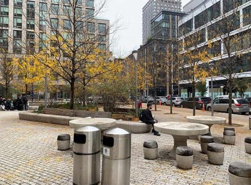
Those of us who cannot access the green rooftops are given a new park on Broome Street at this corner. There are no signs naming this space as it is a POPS, or privately owned public space, in which a developer is given additional floor space or a waiver to a zoning code restriction in exchange for setting aside open space for the public. It’s not the first privately-sponsored park in the neighborhood. Prior to the American Revolution, the SPURA area belonged to the Delancey family, members of the colonial aristocracy. In the 1760s, James Delancey Jr. laid out a street grid across their orchards and it included a sizable open space bound by Eldridge, Essex, Hester and Broome Streets. They were a loyalist family and having lost the war, they fled to Nova Scotia. The Delancey property was then developed by the city but without the big park.
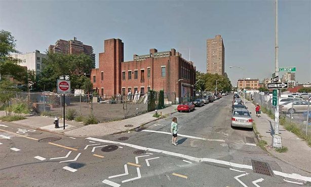
Prior to the development of this unnamed park, this block hosted a firehouse that was built in 1939. In its final years it was leased to a movie prop business. There is another firehouse a couple of blocks to the east. In the decades when the LES was a densely-built immigrant neighborhood, it had more firehouses in response to the higher risk of fires.
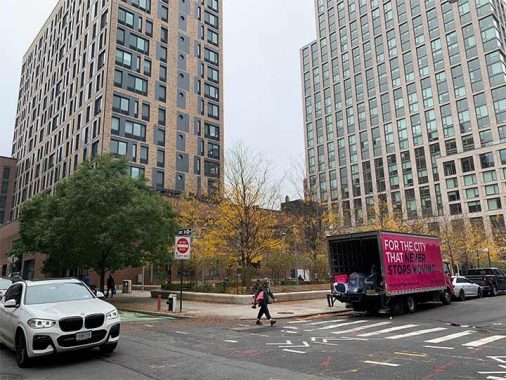
The unnamed park shares its block with The Rollins, a residential tower named for jazz musician Sonny Rollins, who famously spent two years playing his saxophone on the walkway of the Williamsburg Bridge. At that time, he lived nearby in a tenement at 400 Grand Street. IN 2017, a group of Rollins fans proposed renaming the bridge in his honor. With the recent renaming of the Triboro, Tappan Zee, and Queensboro bridges, and the Brooklyn-Battery Tunnel, the public seemed to have grown tired of such things, and the Sonny Rollins Bridge proposal had stalled in the City Council. No true New Yorker speaks of the Triboro as the RFK Bridge, and you can’t make me say it.
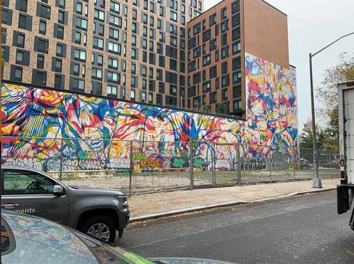
The west side of The Rollins has a floral mural for public view while the adjoining lot awaits development. Kevin Walsh, Frank Jump, and [The Indispensable] Walter Grutchfield have spent decades of their lives exposing fading ads and old murals. After the neighboring lot is developed, I can imagine this mural being exposed again centuries from now by a kindred spirit of these three urban historians.
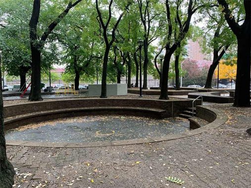
Having mentioned the brutalist NYCHA tower at 64 Essex Street, it has a twin at 164 Broome Street whose brown brick courtyard is covered in circular sitting areas. It appears ideal for a certain local saxophonist as a stage.
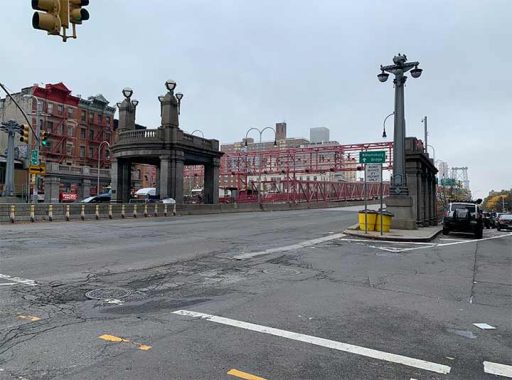
The walkway of the Williamsburg Bridge was redesigned at the turn of the millennium, replacing a staircase in favor of a handicapped-accessible entrance. The pavilion marking the Manhattan landing is an original feature of the bridge that was preserved during its redesign.

Looking back to 1905, we see architect Henry Hornbostel’s sketch for the landing appearing recognizable to today’s traveler. A century before the High Line, this walkway had benches on it, serving as an aboveground linear park for the Lower East Side. If the bridge won’t be renamed, perhaps it’s more fitting to rename the walkway in honor of Rollins.
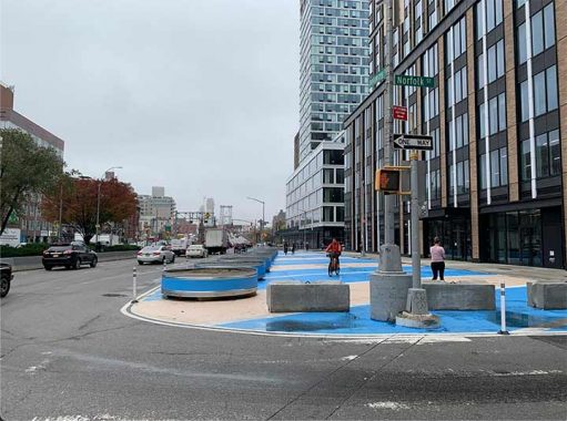
Prior to the construction of this bridge, Delancey Street was widened to accommodate traffic, and beneath the surface, the subway system and a trolley terminal. To improve the flow of traffic and open more public space, the corner of Delancey and Norfolk was given planters and a paint job. Underneath this spot is the abandoned trolley terminal that operated until 1948.


Plenty of ink has been spilled on the history of the abandoned trolley terminal and the unrealized Low Line proposal for this space. Looking at Hornbostel’s sketch for the bridge landing, the trolley terminal had pavilions on two traffic medians, a wide median with a flagpole, and Schiff Parkway running in the middle of Delancey Street. As mentioned in my earlier essay on Sara D. Roosevelt Park, this linear path was narrowed in favor of additional traffic lanes.
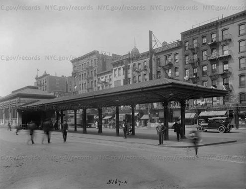
The trolley terminal’s fancy pavilions were torn down shortly after its abandonment as cars were choking the street. In this image from the Municipal Archives, taken in 1918, see how these canopies protected commuters from the elements. Underneath them were Guastavino tiles, which can also be seen under the Queensboro Bridge, the Great Hall at Ellis Island, and the abandoned City Hall loop subway station.
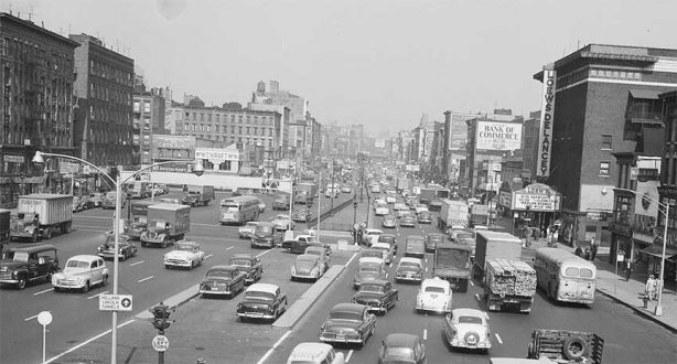
In this image from 1955 from the Municipal Archives, we see Delancey Street congested with vehicles. A sign points the direction to Holland Tunnel, suggesting that many of the vehicles are passing through Manhattan. On the marquee of the Loew’s theater is Rita Hayworth starring in Gilda and Marlon Brando in The Wild One. Next to the theater is the venerable and much-missed Ratner’s kosher dairy restaurant.
[Robert Moses must have plotzed if he saw this photo. -Ed.]
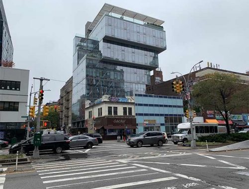
Looking at the north side of Delancey Street, a jewelry shop is shadowed by a top-heavy glass box tower that was designed to clash with the historic streetscape in the same manner as Bernard Tschumi’s nearby BLUE residential tower, an early harbinger of gentrification.
[That thing is monstrous – Ed.]
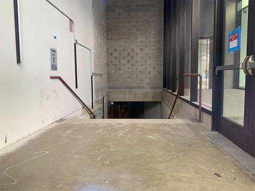
At the time of my visit, only one of The Market Line’s three blocks was completed. Looking at an unfinished entrance, we see a cinderblock wall that will receive a mural, lighting, and other decorations. I thought about venturing down, but I’m not the type to risk arrest for trespassing. I’ll wait until it opens to everyone.
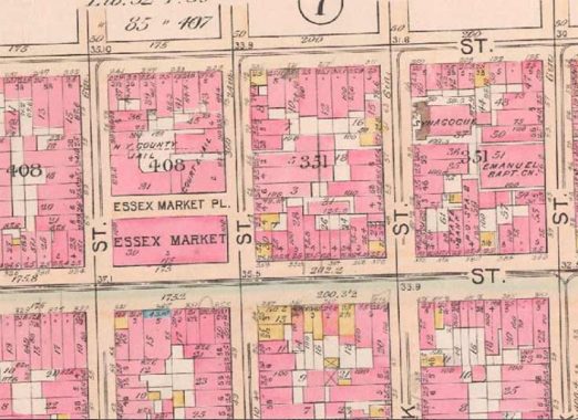
Before I return to Essex Market and the subway ride home, I often finish my essays with maps and photos from the past. Looking at the G. W. Bromley atlas from 1897, we see the site of the first Essex Market, where Seward Park High School now stands. At that time, Grand Street was the main east-west route as it led to the ferry across the East River, where it connected to Grand Street in Brooklyn. Within a decade, Delancey Street was widened, leading to the new bridge and taking away much of the traffic on Grand Street.
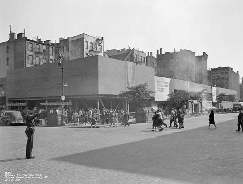
At the site of today’s Essex Market, here is how it appeared in 1939, shortly before completion. Note the lamppost on the corner marking Delancey Street as State Route 27A. In the 1940s, it was cut back to Brooklyn, and in 1970 its western end was scaled further back to Massapequa. Its partner, NY-27 runs from Montauk through Brooklyn, but stops short of reaching Manhattan.

Coming back for one last look at the new Essex Market, the wave pattern on the ceiling makes it an instagrammable spot for a photo and an ideal place to take a stroll when it is cold and rainy.
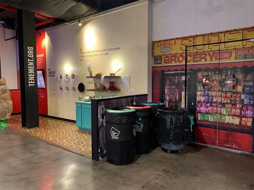
If the food here does not appeal to you, come for the history and art. The Tenement Museum has a display here, next to an illustration of a traditional bodega. Historically they were marked by red and yellow colors, perhaps relating to the flag of Spain or simply the brightness of these two colors. In recent years, many bodegas have updated their awnings with fewer words and colors, sending these old yellow awnings in the same direction as neon signs, pawn shop balls, and luncheonette signs.
You can learn more about the Lower East Side by visiting each of the hyperlinks posted in the essay above. Kevin and I have been to this neighborhood many times. Here are a few recent examples:
Streets of the Lower East Side, 2018
Sergey Kadinsky is the author of Hidden Waters of New York City: A History and Guide to 101 Forgotten Lakes, Ponds, Creeks, and Streams in the Five Boroughs (2016, Countryman Press), adjunct history professor at Touro University and the webmaster of Hidden Waters Blog.
As always, “comment…as you see fit.” I earn a small payment when you click on any ad on the site. Take a look at the new JOBS link in the red toolbar at the top of the page on the desktop version, as I also get a small payment when you view a job via that link.
11/5/23

10 comments
Great posting, but let me take the liberty to add two items.
First, the photo of Delancey Street traffic is from about 1955, based on the vehicles shown. The two buses are NYC Transit Authority models from 1949.
More important, the class 1948 film noir The Naked City has a memorable final scene on the Williamsburg Bridge, including the walkway with benches referenced in this posting. Here’s a YouTube link to the movie: https://www.youtube.com/watch?v=V-W4MZI3T38&t=2131s The scene begins at 1:28.
We played Seward Park High a lot in basketball.We used to call them Sewer Park.
They didnt like that.
I have to still yet to go to Essex Crossing, but that’s mainly due to not being in that neighborhood much, plus its places are probably a lot cheaper than what you would get at the Hudson Yards shops.
I meant to say Essex Market, not Essex Crossing.
And to add a little history to the redesign of the Williamsburg Bridge walkway; by 1985 the bridge was deteriorated to the point that there were serious discussion of taking the bridge down and replacing it with a new one. It seems that years of neglect and the weight of running of all metal subway cars (the bridge was designed for the original wooden chassis subway cars) was stressing the structure beyond repair. The compromise was the rebuilding of both approaches on the Brooklyn and Manhattan side reducing the stress on the main bridge over the river between the towers. The original wide promenade on the bridge was reduced to the more utilitarian walkway there now.
I remember New York Newsday running an article about preliminary designs for the replacement bridge. One that stood out to me was a design that had the replacement having a restaurant on each tower of the bridge.
Someone told me that there are doormen now in that neighborhood just like you
see on Fifth Ave.with the uniforms with the gold braid,epaulets,etc.
Chris,
Re: Seward Park High b-ball, we narrowly escaped Manhattan, by car, after a game there on the night of the big snowstorm back in the early ’80s — then went back
into town, by subway, to walk freely upon the snow-covered, car-free streets! The F/GG trains going up the hill to the Smith-9th station were having a hard time
getting traction, so at one point they stopped running; believe we had to take an N train further towards Sheepshead Bay, then “skitched” over from the rear bumper
of an unsuspecting / not-caring taxicab.
William,
I expect that a *real* NYC transit maven on here can and will elaborate, but I think it was even a bit more intriguing than what you described. I thought I recall reading
that, because the service frequency of the trains using the tracks on one side of the bridge was meaningfully higher than those using the other, the bridge was
detected to be “sagging” towards one side (the south, I’ll claim.) So there was major repair work *and* also service re-routing, to balance out the wear undt tear.
The subway service imbalance you refer to (“because the service frequency of the trains using the tracks on one side of the bridge was meaningfully higher than those using the other, the bridge was detected to be ‘sagging’ towards one side”), was a problem on the Manhattan Bridge, not the Williamsburg. The Manhattan Bridge has identical pairs of tracks on either side of its lower deck, four tracks in all, with a three lane roadway separating the trackways. The Williamsburg Bridge has a pair of subway tracks smack in the middle of the structure, so there is no sway to either side when a train passes. The Williamsburg Bridge closure in 1988 was due to, as I understand, deteriorating cables because the steel was not galvanized when the bridge was built. Had nothing to do with the subway tracks, but of course the J and M trains were suspended for a few months when repairs were made.
Andy,
You know the old saying: you run a subway line over one crummy bridge, and you’ve run a subway line over *all* of ’em…
“Actual”, glad you weighed in to set me, and the record, straight. Take care.