By SERGEY KADINSKY
Forgotten NY correspondent
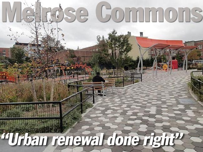
In October 2018 a new park was completed in the center of the Melrose neighborhood in the South Bronx. Previously known as Block 2381 Lot 1, the 1.07-acre Yolanda Garcia Park, facing the east side of Melrose Avenue between East 159th and 160th Streets, commemorates a community leader who fought for those who remained in the neighborhood as it suffered redlining, arson, crime, and wholesale abandonment. When the city drafted urban renewal plans that would have displaced those who stayed, Garcia advocated for affordable housing, along with sustainability and an attractive design. Her organization’s name, Nos Quedamos, translates in Spanish as “we are staying.” The park lies in the center of the redeveloped neighborhood, again vibrant and safe after decades of neglect.
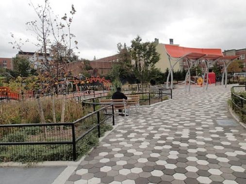
The bright colors of the park’s shade structure and play equipment evokes the parks of Puerto Rico, the birthplace of Garcia. It is a nod to one of New York’s largest ethnic communities, much of which is based in the “boogie down” borough.
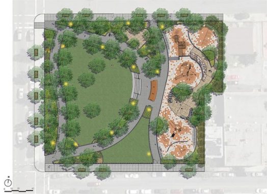
The park contains a sizable lawn that can be used for public events, and a playground facing the lawn. Prior to the 1970s this site had apartment buildings and shops that were abandoned and burned down, when this neighborhood resembled a war zone. At its nadir, some 4,000 residents remained in this forsaken urban setting. Comprising largely of working-class Puerto Ricans, they reclaimed the vacant spaces for community gardens, complete with touches of their birthplace- the wooden casita shacks, roosters, flags, and names hearkening back to la isla encanta. The Puerto Rican flag was invented in New York City in 1895.
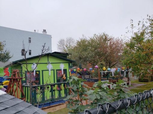
One such example is on the same block as the new park, the .227-acre Jardin de la Roca, named after the bedrock on the lot that pops above the surface. The Bronx is the rockiest of the boroughs with topography that gives it the largest collection of stepped streets, elevated subway lines, and neighborhood names like Mount Eden, Mount Hope, Tremont, Woodlawn Heights, Castle Hill, and Kingsbridge Heights.
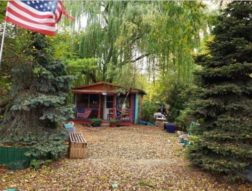
On 163rd Street and Melrose Avenue is Coquí Garden, named after the singing frog that is a cultural symbol of Puerto Rico. On my recent visit to Puerto Rico I noted that the territory’s flags, symbols, and theme murals, are more visible in the Bronx than on the island. Such physical reminders are one way to preserve a unique culture in a new home, along with the vibrant music, art, food, and political scenes.
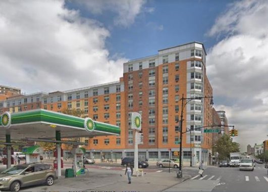
The northwest corner of East 161st Street and Melrose Avenue features the postmodern Courtlandt Corners apartments built in 2010. It fills in a void left vacant in the years when the Bronx was burning. Now turn the clock back to 1938 when this corner had an automobile support shop that offered a driving school, car loans, and license plate applications. When prolific city photographer Percy Loomis Sperr documented this corner, it had what he described as the borough’s tiniest building.
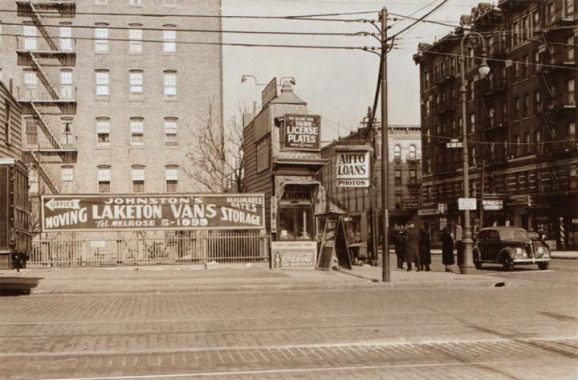
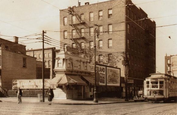
Compensating for its diminutive size, the car business had beauty: a mansard roof, dormer windows, and striped canvas awning from the earlier part of the last century. This shop was merely 3”8.5’ wide and 22” long. It was built in 1902 and initially served as a tailor shop operated by German immigrant Henry Ubelhor. The description appeared in an article titled Freak New York Plots and Buildings, in the March 1914 edition of Real Estate Magazine (p. 81) with the narrowest honor going to the Joseph Richardson “Spite House” at Lexington Avenue and E. 82 Street in Manhattan.
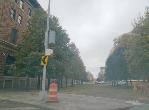
The streets surrounding Boricua College skew from the grid with a northwest bend on Elton Avenue and Brook Avenue which follows the course of the long-buried Mill Brook. The city solved this potential traffic tangle by pedestrianizing the sections of Brook Avenue, E. 162 Street, and E. 161 Street on the block facing Boricua College. In 2015, Kevin walked on E. 161st Street from Yankee Stadium to Third Avenue.
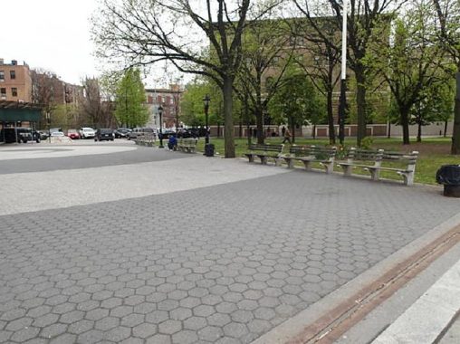
O’Neill Triangle on the southwest side of Boricua College used to be much smaller, but with the pedestrianization of Washington Avenue and E. 161st Street on the triangle’s edges, this .636-acre park has more space in this century. Its namesake remains unclear. Another curiosity in this park is the spiral paving, a decorative feature built on top of the abandoned Port Morris Branch. Is there still a tunnel beneath this park, or was it filled with earth?
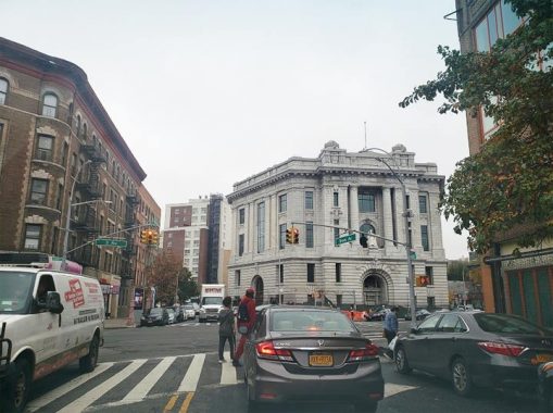
Next to this vertical college campus is a local celebrity with a rich history, the former Bronx County Courthouse at Third Avenue and Brook Avenue. Unlike the other boroughs that had identifiable “county seats,” this borough’s administrative functions were spread out: the first Borough Hall was in Tremont Park; while the courthouse was in Melrose, and the main post office was on E. 149th Street at Grand Concourse. The beaux arts landmark was completed in 1914, the year when the continental part of Manhattan was designated as The Bronx, the city’s youngest borough. The courthouse was abandoned in 1977, the year “when the Bronx was burning.” With the appearance of a classical ruin, the bricked-up courthouse looked over the burned-out shells of apartment buildings and empty lots of a once-flourishing neighborhood. The city auctioned it off to a private developer in 1996. The most recent plan for the old courthouse is to reopen as a charter school.
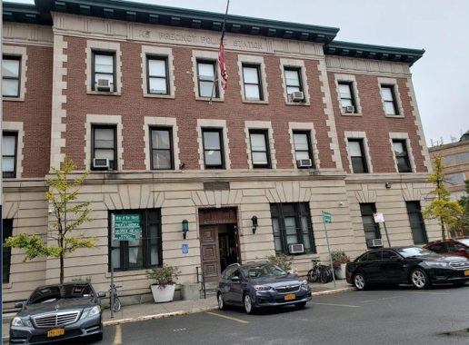
A block to the south of the former courthouse is another early 20th century survivor, the 42nd Precinct. It dates to 1904 and has the look of the former precinct in Kingsbridge Heights, the former “Fort Apache” precinct, and nearly a dozen other former precincts from that generation as documented by FNY’s Gary Fonville.
Although this building has been hosting New York’s finest since Mayor McClellan’s administration, it is not (yet) a city landmark. Noting the sacrifices given by our cops, the street sign in front of the precinct is a totem of names: Det. Philip A. Lamonica, PO George Mead, and Sgt. Walker S. FitzGerald. Another sign on this block honors PO Ronald G. Becker, Jr. The piece of Washington Avenue in front of the precinct was known historically as William Street and today is co-signed as Way of the Finest.
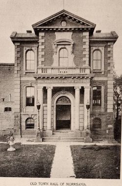
The site of the 42nd Precinct has a long history of civic use. In 1869 Morrisania Town Hall was built here, commissioned by Supervisor William Cauldwell, who is remembered on a nearby avenue. A year earlier, Gouverneur Morris II sold off his family’s holdings in Morrisania to a development company. But a map from 1888 still shows a sizable William H. Morris property and mansion in Morrisania. I’m not sure when the last Morris moved out of their eponymous estate-turned-town. A public referendum in 1873 overwhelmingly backed annexation by NYC. The charming brick structure became a police station after Morrisania was absorbed into NYC. This old town hall brings to mind other former municipal seats that we’ve documented here, such as Flushing, Flatbush, Jamaica, Gravesend, New Utrecht, and New Brighton Village Hall, and Edgewater Village Hall.
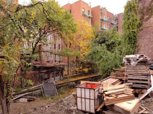
Behind the precinct is a trench without tracks that is the abandoned Port Morris Branch. Built in 1852, this freight spur connected the rail yard at Port Morris with the Harlem Line. At the turn of the 20th century, it was depressed below grade and routed through tunnel beneath St. Mary’s Park. It suffered from tight turns, flooding, and lack of usage. In 1998 the Oak Point Link made this spur obsolete and in 1999 it was abandoned entirely. Relatively easy to access, the former railroad has been a hangout for vagrants and drug addicts. It route has been documented by Nathan Kensinger, the LTV Squad, and Untapped Cities, so I’ll let them describe its history and conditions. Bit by bit, the trench is being filled with new buildings constructed on its route.
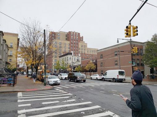
Returning to Yolanda Garcia Park, the view south on Melrose Avenue is a neighborhood transformed. In the place of abandoned lots are charming walk-up with stoops and cornices. Truly admirable about the design of this urban renewal area are its apartments. Instead of cheaply-built brick or glass boxes, notice the stripes.
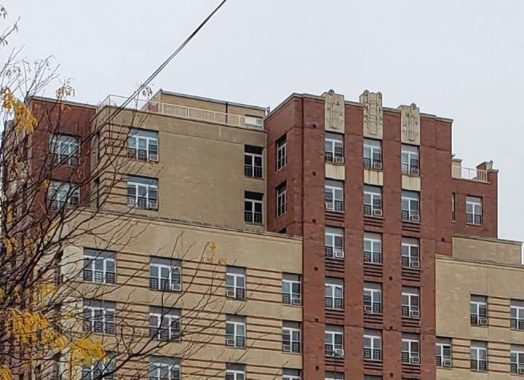
El Jardin de Selene, the given name for 390 E. 158th Street is a rare post-millennial Art Deco revival work. On its main entrance is a floral mosaic, and letters in the deco front spelling out the building’s name. This is urban renewal done right, appreciative of the borough’s history of having the largest collection of Art Deco buildings in the state.
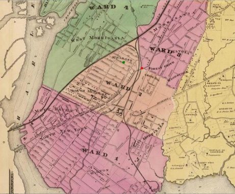
No tour of a historic neighborhood would be complete without a few maps to document its development. The earliest one with Melrose on it is the 1868 F. W. Beers map that shows a grid of named streets. At the time, the town of Morrisania was part of Westchester County, named after its colonial landowner family. Its borders lie within an estate established in the 1670s. On its eastern edge, Bungay Creek took water from present-day Crotona Park to the East River. One can also see Mill Brook running through the town approximating today’s Brook Avenue. North New York was a neighborhood name that fell out of usage over the decades with Mott Haven taking its place. ON this note, South New York was a planned community on Staten Island. East New York is in Brooklyn and West New York is across the Hudson River, rounding out the namesake city’s “neighbors.” for reference I added a green circle for Yolanda Garcia Park and a red one for the former courthouse.
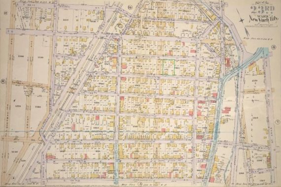
Morrisania was annexed by the county and city of New York in 1873 and Melrose’s named streets were absorbed into Manhattan’s numbered grid. Considering the distance of the blocks, planners added Melrose Avenue to the map, seen in sepia color on this 1887 Elisha Robinson map. This avenue was completed in 1891.
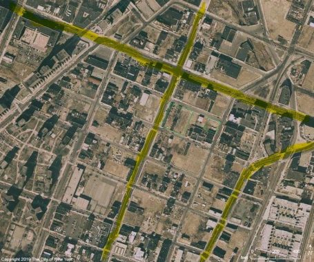
The most recent map for this story is the 1996 aerial survey from the DoITT NYCity Map, which shows a devastated Melrose with barren lots of a depopulated borough. I highlighted Melrose Avenue running north-south, and E. 161st Street going east-west. Also highlighted is Third Avenue, which was shrouded in the shade of the Third Avenue El in 1887, bringing urbanization to Melrose. Its removal in 1973 exemplified the city’s disinvestment in this neighborhood. Today nearly all of these once-empty lots are filled with apartments, schools, businesses, parks, and community gardens. Yolanda Garcia’s vision of a neighborhood reborn has been realized. Her memory lives on in the eponymous park at its center.
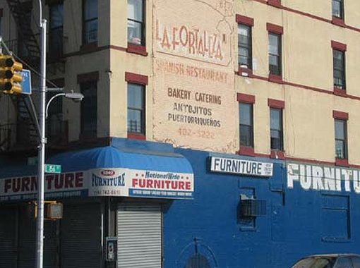
On his visit to The Hub on 149th Street in 2005, Kevin walked north to 156th Street. Sorry to say that the mural ad for La Fortaleza restaurant is gone, but a block to the west on Elton Avenue the Victorian period Greater Eternal Baptist Church still commands attention. When it was built, this was a village of German immigrants, then it underwent a century of transformation. The corner of E. 156th Street and Third Avenue once had an unusual curved dwarf streetlight, because no detail is too small for this website. To the north of Melrose is Morrisania, which Kevin walked in 2011. To its south are Mott Haven and Port Morris, documented by Kevin in 2013.
More from Sergey Kadinsky
The Montauk Cutoff
TWA Hotel: a Quick Look
Sheepshead Bay’s Banner streets
Chelsea’s new park
Sergey Kadinsky is the author of Hidden Waters of New York City: A History and Guide to 101 Forgotten Lakes, Ponds, Creeks, and Streams in the Five Boroughs (2016, Countryman Press) and the webmaster of Hidden Waters Blog.
Check out the ForgottenBook, take a look at the gift shop, and as always, “comment…as you see fit.”
11/17/19

