
I still have grand dreams and ambitions. Publish a book and own my own place? Done years ago. Marriage? Make millions? Let’s not get crazy. However, it popped into my head a week ago that I haven’t listed every street in Manhattan that runs for one and only one block. My criteria for this project were simple. The one-block street should intersect only the two streets where it begins and ends (or one street, if it’s a crescent and begins and ends at the same street) and should not be a section of an interrupted numbered street. And, they cannot be honorific street names slapped onto already existing streets. If I listed those it would entail a separate website.
There are more of these”one and dones” than you think, and with the limited time I have over a weekend, I’ll have to do multiple parts. And this is just Manhattan–there are potentially four other projects to be done for the other four boroughs. Staten Island should be daunting. But I have my extensive photo library and Google Street View/screen capture for those streets I haven’t photographed. I think this is going to be fun.
Before the nitpickers strike, I’m not considering Manhattan’s “slips” for this page, as they are merely extensions of their parent streets. Fear not, though, I covered them here.
Last week I got as far north as Tribeca, Chinatown and the Lower East Side before tiring…let’s see how far I get this week, eh?
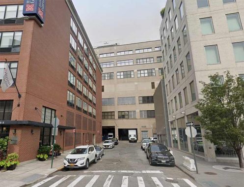
York Street
Tiny York Street, tinier, in fact, than it originally was, is the only street in Manhattan named for its original British namesake, James, then Duke of York, the second son of King Charles I, who was in the royal family when Britain took control of New Netherland in 1664 and renamed it New York. (York Avenue on the east side was named for World War I hero Alvin C. York.) Until 1823, York Street was the eastern extension of Hubert Street, and until 1928 it extended through to West Broadway. The southern extension of 6th Avenue for the new IND subway that year cost York Street about 40 feet now occupied by the 6th Avenue roadbed. York Street, between 6th Avenue and St. John’s Lane north of Beach Street, is only 103 feet long, making it Manhattan’s second-shortest “one and done,” second only to Edgar Street (See Part One).
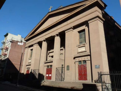
James Street
James Street once ran a full 7 blocks from Park Row southeast to South Street (including James Slip between Cherry and South). Today, only the short piece from St. James Place to Madison remains, and seemingly, that piece was spared to protect what was likely James Street’s most important building, St. James Church, the second oldest building associated with the Roman Catholic Church in NYC. (Old St. Patrick’s Cathedral, Mott and Price Streets, built in 1810, precedes it.) The fieldstone, Doric-columned Greek Revival building was begun in 1835 and completed in 1837; and though it is thought to be a design of famed architect Minard Lefever there is no evidence to support the claim. A domed cupola above the sanctuary was removed decades ago.
You may think James Street was named for St. James Church, but instead it was named for colonial-era distillery owner James Desbrosses. Other Desbrosses family members Catherine and Oliver also have named streets as does Jacques (Desbrosses Street in Tribeca)
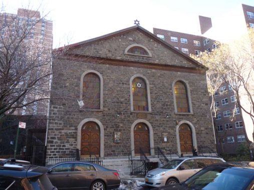
Willett Street
When I covered Cannon Street in Part One, I should also have mentioned its brothers, Willett and Lewis. Willett Street is yet another one of those streets on the Lower East Side that has been truncated to a version much shorter than it once was. These days it runs for a scant block from Grand Street north to Delancey, but before the Samuel Gompers Houses were built in 1964 it ran all the way north to Stanton, which itself was eliminated here decades ago in favor of public housing. Older Hagstroms had just one “t” in Willett, but that’s been corrected in later editions, as the honoree, Marinus Willett, had two “t”s. Willett was a pre-Revolutionary cabinetmaker and sheriff, who later became NYC mayor in 1807 and was, in the post-Revolutionary era, a prominent landowner. A now-vanished adjoining street (Sheriff Street) was also named for him. Since 1987, Willett has had to share street sign space with Bialystoker Place, named for the major edifice on the remaining piece of the street, the Bialystoker Synagogue, built in 1826 as the Willett Street Methodist Episcopal Church and likely the reason this block of Willett was spared (see James Street above).

Lewis Street
Possibly named for Francis Lewis, a colonial-era Town of Flushing resident who signed the Declaration of Independence and has one of Queens’ longest roads named for him (or or his son, Morgan Lewis, a NYS Governor and a chief justice of the Supreme Court), Lewis Street is a two-way route running one block between Delancey and Grand. Though a pedestrian-only section of Broome intersects it, I’m counting it.
There’s something different about Lewis Street. Though most of the Lower East Side’s north-south named streets stop at East Houston Street, Lewis Street once ran north of East Houston Street and broke into the John Randel Commissioners’ grid, ending up all the way north at East 8th; that extension was made in 1828. Today, though, the path of Lewis Street is occupied by the Baruch, Lillian Wald and Jacob Riis housing projects.
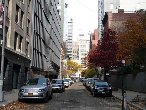
Renwick Street
All the way west to (what I think is SoHo, as it’s north of Canal). I think it was 1992 when I first spotted Renwick Street. In the summer of that year I was freelancing at a type shop named ModKomp, entered from a loading dock on Greenwich near Vandam. This was still in the era when you pulled long galleys of print, cut them and pasted them on boards; there was a lot more dexterity involved in the print business then.
At lunch I would take long walks in the neighborhood. Real estate barons hadn’t yet dubbed the area Hudson Square, so this was a part of western Soho or even the West Village and it was wholly industrial, with the exception of a couple of bars here and there like the Ear Inn on Spring.
And, there it was, emanating north from the honking cacaphony of Canal and a couple blocks from the earsplitting madness of West… tiny Renwick Street. It’s one of an odd trio of one-or two-block streets that run north-south parallelling Hudson and Greenwich.
I recently went over and squeezed out some photos of Renwick Street, which are a bit different from how it looked in 2008.

Centre Market Place
Centre Market Place is a one-block street in Manhattan’s Little Italy. It runs between Grand and Broome Street on the eastern end of the 1905 former NYPD Headquarters. When I first saw it on street maps as a kid, I had thought it was the northern end of Baxter Street (originally called Orange Street) but the two streets are slightly off line, so that was likely never the case. The street is named for a wholesaler called the New York Central Market, which occupied the parallelogram formed by Centre Street, Broome, Grand and Centre Market Place between 1817 and just before the Police Building was built in 1905; it was likely a complement to downtown’s Washington Market, where the present Independence Plaza Apartments are now. The street acquired the Centre Market Place name in 1837, though it doesn’t show up on maps until the early 1900s. It was formerly home to gun dealers and the quirky street photographer Weegie.
Note the difference between Central Market and Centre Market. It’s possible that the name of Centre Market Place was influenced by the nearby Centre Street. Both streets use the British spelling of centre, which was likely also still current in the USA in the early 1800s before Noah Webster revolutionized American spelling.
As Mitch Waxman says about what he does for the Newtown Pentacle, I “cracked out” some shots of Centre Market Place for a FNY page in 2014, and more during a recent Soho walk which will pop up when I write that page.
Weehawken Street
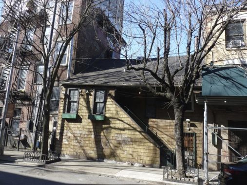
By some accounts “Weehawken” is derived from a Lenape Indian phrase meaning “rocks that look like trees.” Weehawken Street, which runs between Christopher and West 10th Streets just east of West Street, stands on what, in the colonial era, was on the grounds of the Newgate State Prison. Nearby Charles Lane (see below) is a Belgian-blocked alley that used to run along the prison’s north wall.
#6 Weehawken also fronts on West Street and is known as#392-392 West Street. By many accounts it is the only building left over from the old Weehawken Market and one of the few wood-frame buildings left in Manhattan. It had been in a row of similar buildings that had all been demolished by 1937.
Ready for a deep dive into Weehawken Street? FNY has it covered.
Charles Lane
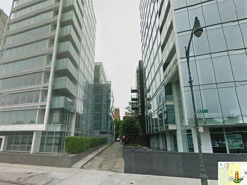
Only one tangible remnant of the Newgate Prison still exists today, the narrow, sidewalk-absented Charles Lane, which marked the northern boundary of the prison property. It appears on this 1885 map, but the City officially mapped it on official records beginning in 1893, when it gained its unusual brick paving.
The west end of Charles Lane was irrevocably altered in 2002 and again in 2006 when this pair of Richard Meier-designed glass front apartment houses arrived. The narrow brick width of Charles Lane between the two buildings (and the retro Corvington lamppost) are a little bit of 1910 in the midst of a whole lotta 21st Century.
Jones Street
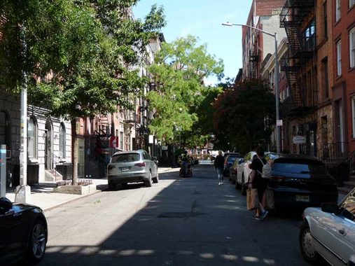
The first of a pair (with Cornelia Street; see below) of one-block Greenwich Village streets between Bleecker and West 4th Street west of 6th Avenue, Jones Street was named for Dr. Gardiner Jones, on whose land the city constructed the street in the early 1800s. Great Jones Street, running between Broadway and the4 Bowery in the place of East 3rd Street, and the intersecting privatized Jones Alley were named for his brother-in-law, a renowned lawyer, Samuel Jones. (The “Great” in Great Jones Street refers to its relative substantial width in comparison to the usual in the 1800s, not lawyer Jones’ fame.)
The Greenwich Village Jones Street’s most well-known appearance was on the cover of “The Freewheelin’ Bob Dylan” in which the songsmith is seen walking with his girlfriend, the late Suze Rutolo, on a snowy day in 1962. While a “Mr. Jones” appears in a later Dylan song, “Ballad of a Thin Man,” Dylan stated he was writing about a specific person not named Jones; since he wanted a generic name, he may have decided to use the relatively anonymous-sounding Jones Street in the Village.
Cornelia Street
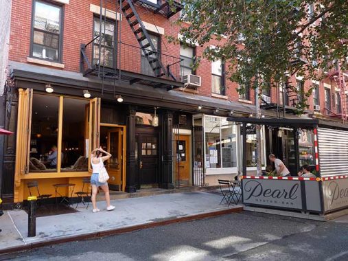
Jones Street’s parallel, Cornelia Street, is popular for its restaurants and bars such as Figure Eight and Palma, as well as the jazz club Cornelia Street Cafe (closed in 2018); unfortunately the Pearl Oyster Bar, in this shot from September 2021, has also since shuttered. There are a number of streets with women’s given names in lower Manhattan, most of them famed not in their own right but for being wives of wealthy landowners, in this case either Cornelia Herring (or Haring) or Cornelia Rutgers.
I remember a basement record store but forget the name. As always… Comments are open.
{Subterranean Records; see Comments]
Minetta Street
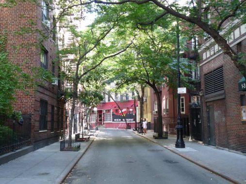
Two tiny streets in the heart of Greenwich Village, Minetta Street and Minetta Lane, are named for the brook that originally arouse in midtown in the Madison Square area (5th Avenue and 20th Street) and meandered southwest through Washington Square and draining into the Hudson River in a marshy area at about Houston Street. In the colonial era, it was known as Richmond Hill; in a grand dwelling built by British Army Major Abraham Mortier, George Washington made his headquarters during the Revolutionary War and John Adams and Aaron Burr later made their homes.
Minetta Brook had apparently been moved underground for the most part by 1830, but other than the two lanes named for it, it still makes its presence felt in Manhattan. Some property lines are still angled to mark its passing, and a fountain at #2 Fifth Avenue, just north of Washington Square, used to occasionally fill with Minetta Brook water, though it seems to have dried up (the fountain, not the brook) in recent years. The name of the brook was originally a Native American word, manette or “devil water” and the term was filtered through Dutch as Mintje Kill from the Dutch word for “little “plus a diminutive term (from which English gets its “-ie” as a familiar or diminutive suffix) and kill, stream.
Both Minetta Street, which follows a curved course matching the stream between 6th avenue and Minetta Lane, and Minetta Lane, which runs straight from 6th Avenue to MacDougal Street, were on maps by the 1860s, but they were often rendered with nonstandard spellings like “Minetto” before cartographers settled on the current spelling by 1875 or so.
I’m citing just Minetta Street on this page, since it runs one block from 6th Avenue and Bleecker Street on a banded path to Minetta Lane. The latter can’t be in the club, since it intersects three streets: 6th Avenue, Minetta Street and Macdougal Street. I deal with both Minettas on this FNY page.
Gay Street
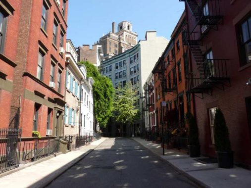
Between Waverly and Christopher just west of 6th Avenue is a short dogleg called Gay Street, which contains a number of handsome Federal-style buildings and has a varied lore. The name of the street predates Greenwich Village’s gay community by several decades, but the derivation is in dispute. In Naming New York, Sanna Feirstein claims it was named for Sidney Howard Gay (1814-1888), editor of the Chicago and New York Tribunes and a prominent abolitionist, but in The Street Book, Henry Moscow says the name ‘Gay Street’ appears in the Common Council minutes of 4/12/1827 — when Sidney Howard Gay was thirteen. The short lane is probably named for a local landowner in the mid-1820s, the years in which the street was first established.
Here’s a closer look at Gay Street from FNY.
Washington Mews
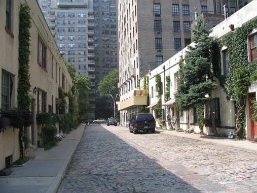
Washington Mews is a through alley between 5th Avenue and University Place just north of Washington Square, and is lined with charming two-story cottages that were, at least on the south side, formerly stables used by the well-to-do residents of Washington Square North, the adventures of which were described in 19th Century novels by Henry James. It is the only street in NYC called a “mews” though there are many “mewses” in London. It is marked by an old-style serifed street sign on the corner building on 5th Avenue. The dwellings on the south side were constructed from 1850-1880 while the ones on the north side, in the 20th Century. It’s just one of many NYC streets named for George Washington.
The term “mews” is unusual: it derives from a French word meaning “to moult” and mewses were originally used in the 1300s to place cages confining falcons and hawks (used by royalty for sport) while they shed their feathers. Only later were the alleys used to house carriages.
Just around the corner, at #3 Washington Square North and University Place, was the studio where the great painter Edward Hopper lived and worked from 1913 until his death in 1967.
Taras Shevchenko Place
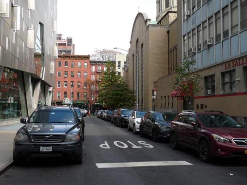
Taras Shevchenko Place is a mouthful, especially when you realize that it was Hall Place before 1978. That year, the street was renamed for a revered 19th century Ukrainian writer, artist and political activist. The East Village near Cooper square has long been a Russian/Ukrainian enclave. Were the street renamed today, Hall Place would be retained and an extra street sign would have been added. A few years ago, during a street sign replacement kick, the Department of Transportation actually reinstalled a Hall Place sign, but it’s since been removed.
NYC streets north of Houston Street and outside of Greenwich Village are notably bereft of midblock short streets and alleys (Unlike, say, Philly and San Francisco) so short blocks like Shevchenko Place are rare. When you have such an alley, there’s usually a story behind it, and Hall Place (named for a previous landowner) was the east end of the 19th-Century Tompkins Market:
The Tompkins Market stood on the small city block bounded by Sixth Street, Seventh Street, Hall Place and Third Avenue, where the newest Cooper Union building 41 Cooper Square, now stands. The first Tompkins Market opened here in 1830, but the most famous was the 1860 cast iron building designed by James Bogardus. This building contained the public market on the first floor, and the armory and drill rooms of the Seventh Regiment of the New York State National Guard on the second and third floors – an unusual combination in the 19th century or today. The public markets were the place where the best meat and fish, butter, milk, and cheese, the freshest vegetables, fruits in season and “exotic fruits” – bananas and grapefruit – could be found. The inventory of the 1860’s market would astound the shopper of today. [Cooper Union]
According to the article, the market and then the 69th Regiment Armory occupied the building, which was torn down in the mid-1910s.
Next Time: Midtown and Uptown
As always, “comment…as you see fit.” I earn a small payment when you click on any ad on the site. Take a look at the new JOBS link in the red toolbar at the top of the page on the desktop version, as I also get a small payment when you view a job via that link.
2/18/24

10 comments
How about doing dead end streets in Manahattan, I’m sure there are a few
Check my Alleys category under Search By Categories on the right side of the page
The Bialystoker Synagogue deserves a bit more mention. According to Wikipedia, it is the oldest building used as a Jewish synagogue in New York City. The congregation was founded by a group of Jews who came from the city of Białystok, Poland, the namesake of the bagel offshoot known as the bialys. It is bagel shaped but instead of a hole has a depressed center that is closed. It is not boiled like a bagel, but is baked, usually with a bit of onion flavoring.
The areas surrounding Bialystok were part of a large concentration of Eastern European (Ashkenazic) Jews who were under Russian rule until after World War I, when an independent Poland was created. Large numbers of them emigrated to the United States between the 1880 and 1914, among whom was my maternal grandmother, born in Lomza, Poland, a city about fifty miles west of Bialystok. Born in 1896, she came to the US as a young child around 1901 and had few memories of Poland. She was alive until I was 35 years old so I knew her well.
If memory serves, the hair-adjusting pedestrian in the Cornelia Street shot is passing the former location of Mario Batali’s “Po”
Ristorante.
The record store on Cornelia Street was Subterranean Records. It was at #5 underneath the restaurant. It was run by Mike Carlucci and closed in early 2008.
I think Berenice Abbott photographed Weehawken st. before most of it was razed in that book
Changing NY
Charles Lane also happened to be the name of a character actor who played Scrooge-like characters (though, not to my recollection, ever old Ebenezer himself). If you IMDb him you’ll recognize him instantly if you watch TV from the 1950’s and 1960’s.
<> Creepy. How long was she dead? She looks pretty good there.
https://www.youtube.com/watch?v=v17lMr0j2D8
Prior to Subterranean Records, Record Runner occupied the space at 5 Cornelia St in the ’80s.