

I don’t get down to Far Rockaway that much, alas. In fact, it’s been a decade (as of 2023) since I have done a deep dive down there. Fortunately, Sergey’s work takes him all over and he has sent along a new examination. Plenty has changed, it seems, since a decade ago.
By SERGEY KADINSKY
Forgotten New York correspondent
PHYSICALLY separate from the rest of Queens by Jamaica Bay, the Rockaway peninsula feels like a separate city and if it were, its commercial and political seat would be Far Rockaway, with its downtown on Mott Avenue. In 2023, Borough President Donovan Richards, who previously served as the neighborhood’s councilman, celebrated the completion of Rockaway Village, a set of affordable apartments and shops on the superblock between the subway and railroad terminals. Like any other post-millennial development, it has hints of its past that make it worthy of a Forgotten-NY essay.
On the subway map, Far Rockaway-Mott Avenue is the easternmost station on the longest line in the system, which provides a one-seat ride to Inwood, Manhattan. The portion of the A train in the Rockaways was originally part of Long Island Railroad’s Rockaway Beach and Far Rockaway branches. Prior to 1955, the commuter railway had trains running the length of the peninsula, connecting to the Five Towns and the mainland of Queens. With the acquisition of this rail line by the subway system, the link to the Five Towns was severed. A new elevated terminal was completed in 1958 with an island platform and lobby on Mott Street.
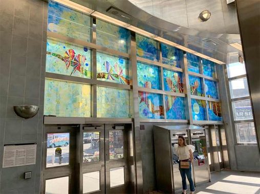
In 2011, MTA commissioned artist Jason Rohfl to design stained glass panels to beautify the station. Titled Respite, the work shows an abstract landscape of birds perched on outstretched branches.

Next to the station, the O’Kane Building serves as its longtime companion. When it was built in the 1930s, the train tracks were at grade crossing Mott Avenue on their way to the Five Towns. In 1942, the line was elevated as traffic increased on the streets. After the LIRR gave up the train line in 1956, the trestle across Mott Avenue was removed and the tracks terminated next to this building. Vacant at the turn of the millennium, this building was recently restored to function again as an office space.
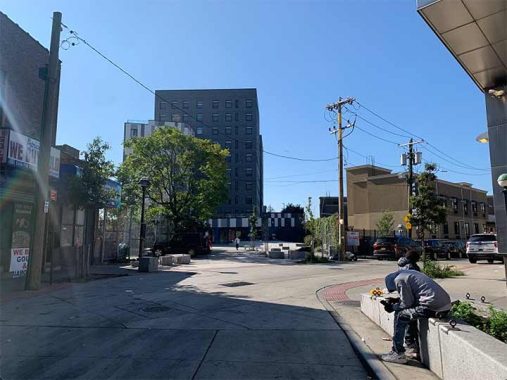
Next to the station used to be a public parking lot and outdoor bus terminal. Responding to the demand for housing, it was developed in 2021. The driveway here was transformed into a plaza connecting this apartment building to the station.

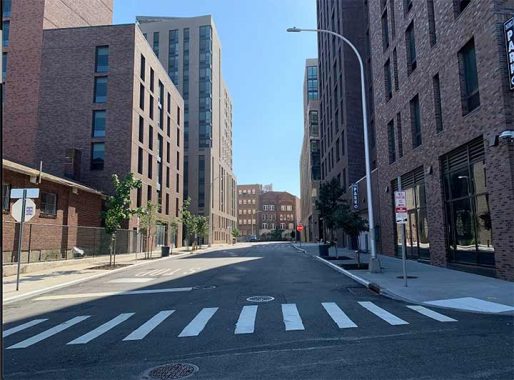
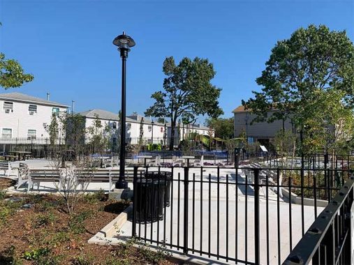
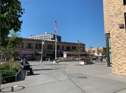
The greatest streetscape transformation is across Mott Avenue from this station. After the LIRR cut back its tracks to Nameoke Avenue, the superblock here was developed as a shopping strip with a massive parking lot. But it never attracted a nationally renowned retailer and was regarded as an eyesore. For more than a half century, residents imagined this flat space as an urban center but it took until 2018 for city officials to announce its redevelopment: eight towers hosting retail, health center, offices, and apartments. The pedestrian street here is a POPS: privately-owned public space, named for the Stark family who owned this property when it was a strip mall.

“This is the first thing residents see when they get off the A train and it says people don’t care about us,” Richards said at the time. “This was supposed to be the anchor of the community. This project is for people who live here, who have had to walk past that site all these years. It’s a great moment for Rockaway.”

The Rockaway Village complex includes a new street, Village Lane and a pedestrian alley but it wasn’t without controversy. The sculpture in the alley resulted in head-scratching by some passersby on its meaning and intent. No parking allowed on Village Lane as it is a private road open to the public. Contrary to its name, Village Lane has a very urban appearance.

On the northern edge of Rockaway Village at Redfern Avenue is a scene of the old and new. The Living Rock church used to have empty lots as its neighbors, but now it has hundreds of potential congregants around it. In comparison to Hunters Point and Battery Park City, recently planned communities usually don’t have space reserved for a church or temple.
Looking south, the twin arches of 16-12 Central Avenue are more than a century old. If this building could talk, it would speak of having faced a railyard, then a shopping strip parking lot, and now looking straight towards Village Lane, the newest street in Far Rockaway.

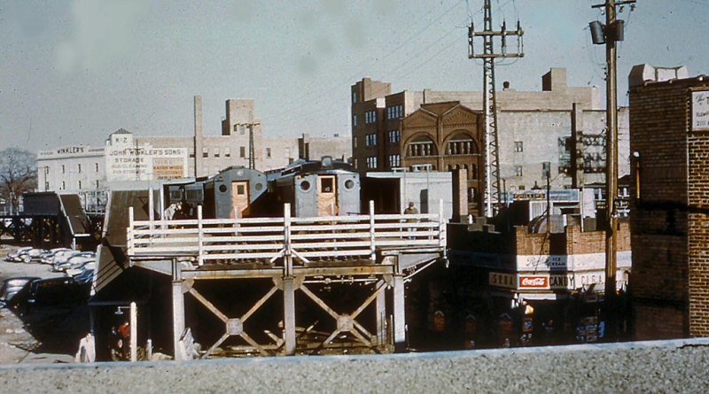
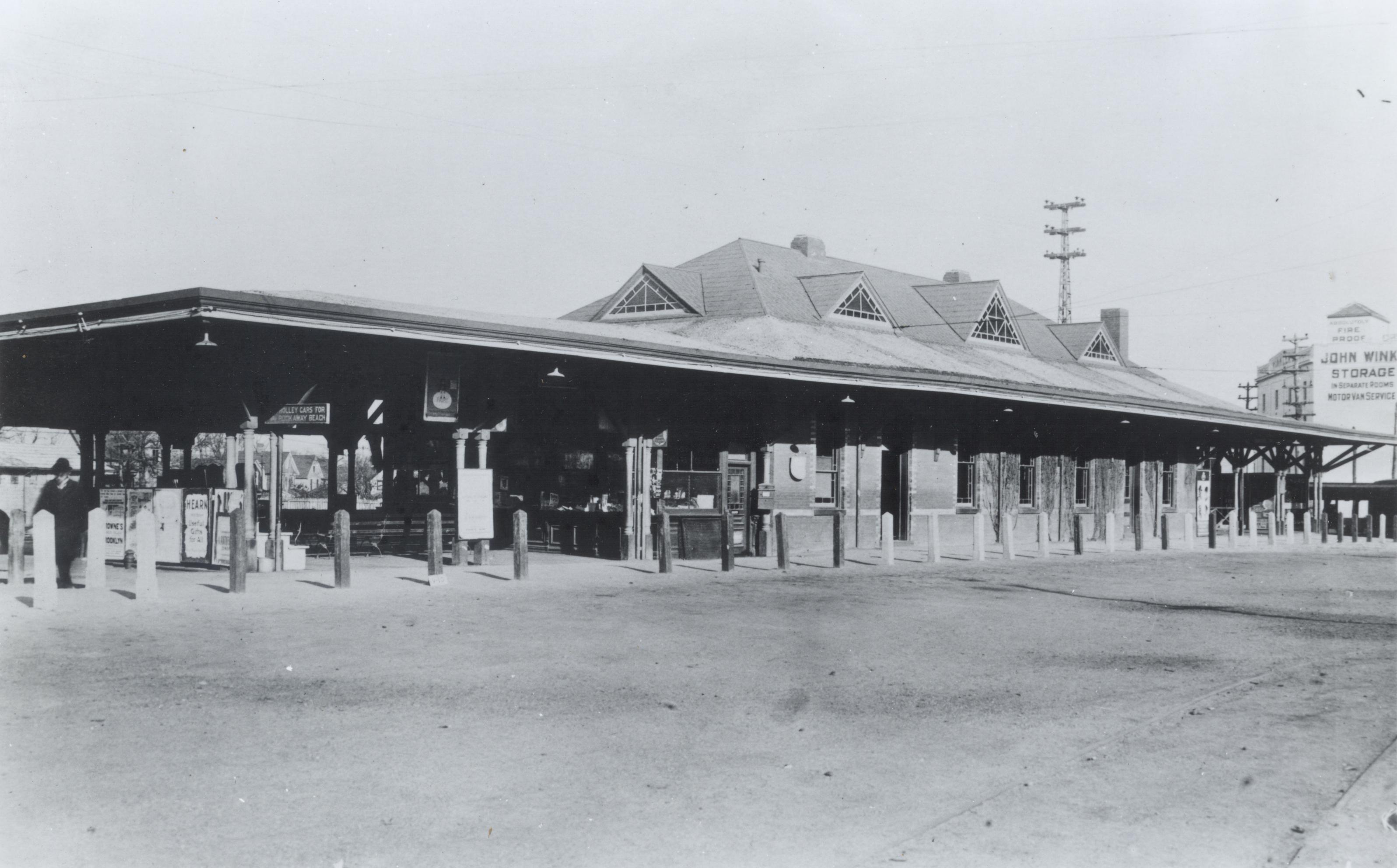
A postcard from the 1920s taken from the roof of the O’Kane Building looks towards 15-20 Central Avenue with the railroad and station between them. Next to the trains was a trolley that connected the Far Rockaway station to the beach. The station and its railyard opened in 1869 and expanded over the decades. Its station house was demolished in 1957 in favor of the strip mall, but the design is similar to other stations on this line at Woodmere, Cedarhurst, and Lawrence.

At the five-point intersection of Nameoke Avenue, Redfern Avenue, and Hassock Street is a colorful apartment building that replaced a vacant church. Next to it is the Far Rockaway LIRR terminal. Prior to 1956, the tracks crossed Nameoke Avenue on a trestle and continued on the peninsula to Beach 116th Street. In contrast to the subway terminal, when this facility opened in 1958, it appeared as an afterthought in a decade when cars overtook trains as the primary form of commuting. It is the only station on this line with an island platform.

Nothing architecturally creative about this station, which initially was a brick box that was replaced with a glass shelter in 2021. Perhaps in the near future it will receive its own upgrade with public art to fit better with the scenery of Rockaway Village. It is the only station on the Far Rockaway Branch that charges the reduced city fare, offering a one-seat ride to Penn Station, Atlantic Terminal, and Grand Central.
,%20NY%20(View%20N)%20-%2006-02-62%20(Faxon,%20Jr.-Keller).jpg)
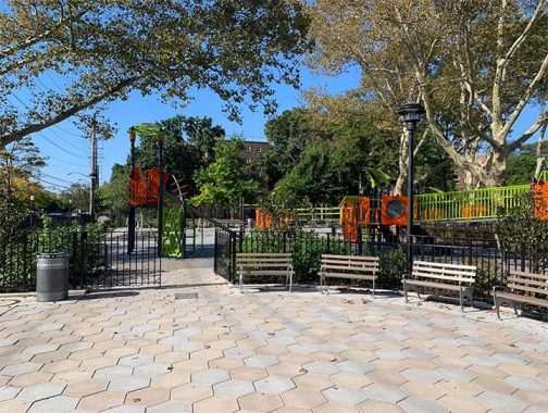
Further to the east on Redfern Avenue is the NYCHA complex and playground that share its name. In 2023 the playground was renovated with updated play equipment but what makes it worthy of Forgotten New York is the dead-end of Beach 12th Street next to it.


Behind the playground is the city line where Beach 12th Streetentered Nassau County to become Walcott Avenue. With the renovation, it was transformed into a dead-end making a very visible border between the two counties. (A sidewalk crosses the undefended Queens-Nassau border, but cars cannot pass–ed.)
The Redfern Houses were completed in 1952 as a slum clearance project that displaced a community of nearly 2,000 Black households who lived on this “side of the tracks.” Over the decades, this complex had its share of negative headlines relating to gang violence.
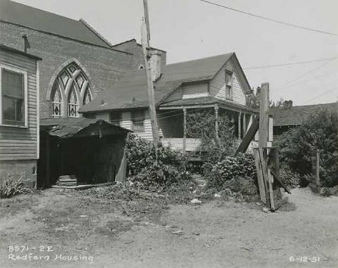
The city argued that the homes here were in poor condition, which the residents blamed on their landlords for failing to maintain. Their destruction was the first example of urban renewal in the Rockaways, which would be followed in the next decade with five more NYCHA developments.
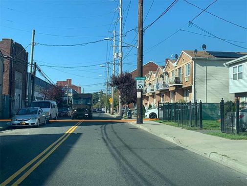
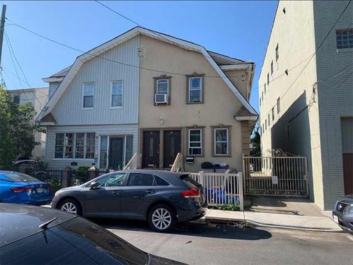
Further east, the border between Far Rockaway and Inwood on Redfern Avenue is subtle, identified by parking signs and the change in addresses. Next to the rowhouse on 11-50 Redfern in Far Rockaway is the unattached house 48 Redfern Avenue in Inwood. In front of this home, a lamppost has a “Far Rockaway” sign in the font of Nassau’s hamlets and villages, and a sign that the speed limit is 30, but within a few feet the law reduces it to 25. On most roads that enter NYC, there is usually a large sign reminding drivers that they’ve entered the city and not to turn left on a red signal. I drew an orange line on this photo to mark the undefended border.
Nameoke Avenue runs to the south of the LIRR terminal and has a new $6.26M park on the corner of Augustina Avenue. It is a Native name, pronounced “name-oak” after the Nameoke Park resort that was built around 1905. Robert S. Grumet’s encyclopedic book Manhattan to Minisink: American Indian Place Names of Greater New York and Vicinity quotes its name as Mohegan for “fishing place,” and its popular use is from the 1839 romantic novel Nix’s Mate, where Nameoke is a chief’s daughter in New England.

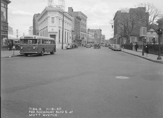
On the opposite side of the park on this intersection are a couple of auto repair garages that have stood here since the early 20th century, as seen here in 1940, and a year later when the tracks were elevated.

The corner of Augustina Avenue and Bayport Place faced an empty lot for decades after the railyard closed in 1956. In 2020, construction began on Rockaway Village and this corner now faces a set of new apartment towers. To the left of this corner is the neighborhood’s telephone exchange building.
South of Central Avenue, there are a couple of unusual houses on Bayport Place. The attached homes at 11-35 and 11-37 show what happens when property owners do not agree on the exterior look. Such examples can be seen throughout the city.

The owner of the house at 11-26 has a painted exterior of red polygons on a white wall that looks like bricks from a distance. Points for creativity for putting colors on concrete. This home was built in the early 20th century, when such buildings either served as summer residences or hotels. Some of these homes were later settled by large families or subdivided into smaller units.
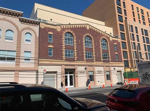
At 15-20 Central Avenue, Challenge Charter High School has classes in a restored building that dates to the early 20th century. I initially thought that it was a former church or Masonic hall, but it was built by John Winkler & Sons storage warehouse.

The Pentecostal church at 16-18 Central Avenue still has Rockaway News on its facade, a reminder from a time when there were many newspapers covering the Rockaways. This one operated from 1900 to 1941. Only one peninsular newspaper remains today, The Wave.
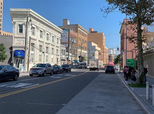
One door down from the former Rockaway News is the Flatiron of Far Rockaway, built as the Far Rockaway National Bank around 1910. It also hosted the office of developer Lewis H. May, whose name appears on Lewmay Road in Edgemere. The backside of this building faced the Ocean Electric Railway Company trolley tracks that connected the train station to the beach. In recent decades it served as a medical center. With Rockaway Village, the back of this former bank touches on the towers of Rockaway Village.
In this 1940 view of Central Avenue looking east, from the Municipal Archives, we see National Bank on the left, with the firehouse, magistrate’s court, and library on the right. I do not know exactly when the former village hall was demolished and I find it ironic that the post-millennial complex nearby puts “village” back on the map of Far Rockaway.
On the corner of Central and Mott Avenues is a new plaza that serves as a visual corridor between the public library and the subway terminal. Prior to the Rockaway Village project, there was a turning lane here, and throughout the city spaces for cars are being pedestrianized. The smallest piece of federal property anywhere is a mailbox, and when this plaza was expanded, the mailbox was restored to where it stood before.
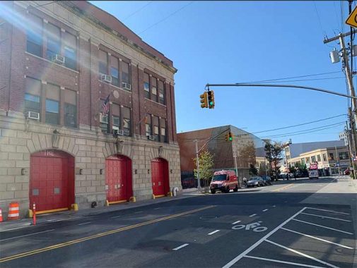
Across Central Avenue are three structures that demonstrate this block’s place as the civic center of Far Rockaway: the firehouse, site of its village hall, and the library. The landmarked Engine Companies 264 & 328 / Ladder Company 134 is a grand structure completed in 1912 in the Renaissance Revival style.
The first firehouse on this site was built in 1887 by the Far Rockaway Volunteer Fire Department. It was absorbed into the FDNY in 1905 and given its new firehouse shortly thereafter. In this postcard from the first decade of the 20th century, we see the original wooden firehouse next to the local magistrate’s court.

The parking lot of the firehouse does not have any historical plaques to speak of its history but this was the political center of the community prior to its annexation by New York City. In the mid-19th century, Benjamin Mott (1820-1905) donated this parcel to a public school and it later became the Village Hall. He was a descendant of colonial settlers whose name appears on Mott Avenue and its subway terminal. Far Rockaway was incorporated as a village within the Town of Hempstead in 1888, with Mott serving as one of its trustees. The village president, Edmund J. Healy also appears on the map with Healy Avenue in Bayswater, and the Healy Building at 10-45 Beach 20th Street.
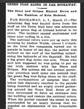
During the brief existence of the village government, it experienced a nationalist episode on St. Patrick’s Day in 1894 when a janitor named Walsh (no relation to Kevin) hoisted a green flag with a harp on the building. It was reported in the New York Times. Walsh’s flag was often used by the Fenians, an immigrant movement that advocated for Irish independence from the U.K. The peninsula has plenty of Irish history, most notably on its western tip at Breezy Point.
In 1898, the villages of Far Rockaway, Arverne-by-the-Sea, and Rockaway Park, and other peninsular communities, seceded from Hempstead to merge with the great city.


The former Village Hall became a police precinct, and then hosted the magistrate’s court until it relocated to Beach 90th Street in 1931. For more examples of former municipal seats across the city, I have an essay on the former Town Halls of Jamaica, Newtown, Morrisania, New Utrecht & Gravesend, and the village of New Brighton. Kevin documented the Town Halls of Flushing and Flatbush, and the village of Edgewater. When Far Rockaway became part of NYC, Healy’s job title changed but not his workplace as he became the local magistrate judge.
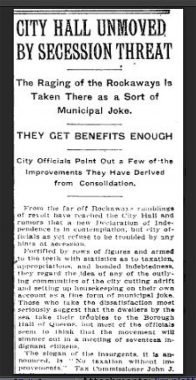
Speaking of Edgewater, Staten Island has a long history of secessionism, and so does Far Rockaway on account of its geographic isolation. A New York Times article from 1910 quotes their slogan “no taxation without improvements.” Its sense of identity was exemplified in late 2012 after Hurricane Sandy severed the subway to the mainland. For six months, the H train was revived as a free shuttle running from Far Rockaway to Beach 90th Street, and many residents bought hoodies with its H logo.
For other disused train identifications, see Thank You For Your Service.

Next to the library is a sign announcing destinations on Nassau-bound bus destinations. At the time, Lawrence, Cedarhurst, Woodmere, and Hewlett were not as developed, and many of their residents traveled to Far Rockaway’s downtown for shopping and work. Across the county line, East Rockaway, Rockaway Turnpike, and Rockaway Avenue share its anglicized Native name, which translates either as “place of our own” or “sandy place.” To this day, Nassau County buses N31 and N32 stop here on their way east.
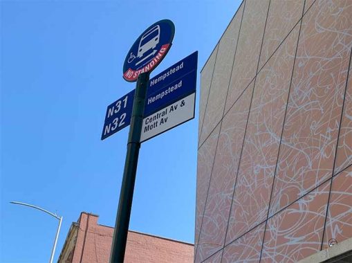
Looking at the bus stop today, the same routes appear on a city-issued bus stop sign. How history would have turned out had Hempstead agreed to join NYC in 1898. Not only would all bus stop signs on these two routes appear like this, but the street grid number that starts at the East River would have counted beyond 500th Street!
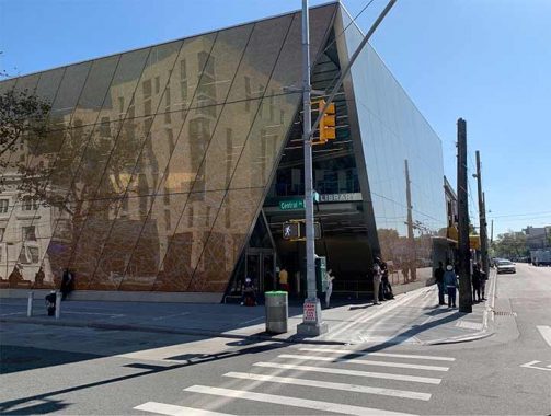
Within a year of Superstorm Sandy, the firm Snohetta drew a postmodern design for the library’s third version. Twice the size of the previous library, the pyramidal structure is fully accessible and won a number of architectural awards. The colors of its glass exterior evoke the sunsets of the Rockaways. I could wait here until the library opens, continue further on the commercial strip as Central Avenue becomes Beach 20th Street, or return to the subway.
You can learn more about Far Rockaway by visiting each of the hyperlinks posted in the essay above. Kevin has been to this neighborhood and its environs many times. Here are a few examples:
Borderline Crazy, Part III: Far Rockaway, Queens, 2003Alleys of Rockaway Beach, 2003
Sergey Kadinsky is the author of Hidden Waters of New York City: A History and Guide to 101 Forgotten Lakes, Ponds, Creeks, and Streams in the Five Boroughs (2016, Countryman Press), adjunct history professor at Touro University and the webmaster of Hidden Waters Blog.
As always, “comment…as you see fit.” I earn a small payment when you click on any ad on the site. Take a look at the new JOBS link in the red toolbar at the top of the page on the desktop version, as I also get a small payment when you view a job via that link.
10/8/23
7 comments
wow has that place changed!
I grew up in Cedarhurst and we used to find railroad spikes in our yard when we were kids and went digging around. Our house was about half a mile from the LIRR tracks, so I was wondering if the old “A train” like that went into the “Five Towns” didn’t take the path of the current LIRR
Look up Cedarhurst Cutoff. It was a line that ran along Arbuckle Avenue and Branch Boulevard. It was abandoned in 1934.
the far rockaway branch used to but does not currently offer any one seat rides to atlantic terminal. might come back in the future, but this warrants a correction
Do you have any data regarding any children’s convalescent homes on or near Queens and/or Far Rockaway from the 1930’s, 1940’s? My mother was a child that was sent to a convalescent home either in Queens or Far Rockway after having surgery at Bellevue hospital, between 1936 – 1940. I am trying to find where she was located during that timeframe. She became a ward of the State of New York, and she could not recall the name of the school, and she has since passed away.
This article was so informative it really does make me miss home but it’s nice to see how it has grown and developed over the years.
I always thought the “Far” in Far Rockaway was for it’s distance from Manhattan. I read somewhere that Far Rockaway and Near Rockaway on Long Island were named for their proximity to Hempstead Village. And it dates back to when the Rockaway Peninsula was part of the Town of Heampstead.