
BY SERGEY KADINSKY
Forgotten NY correspondent
At the end of 2023, the ribbon was cut on the East Midtown Greenway, an elevated walkway built above the water, connecting East 54th Street to Andrew Haswell Green Park on East 60th Street. It brought public access to a stretch of shoreline that was inaccessible to the public for more than 80 years!
The path helps fulfill a decades-long dream of park advocates to enable the public to circumnavigate Manhattan’s shoreline by foot or bike on linear parks that follow the water’s edge. Examples of such paths include Hudson River Park, East River Park, Stuyvesant Cove Park, and Riverside Park. On the FDR Drive, one can walk along the seawall between Triborough (RFK) Bridge and 60th Street. The opening of this greenway is part of the vision to extend the shoreline walk along the entirety of Manhattan’s east side.
[The UN area is one of the last pieces of the puzzle, as security is a factor; the city has a plan and is scheduled to construct a walkway similar to this one in the next few years. — Ed.]

Like the High Line, this park is thin, has multiple biomes, and a tunnel section on its seven-block stretch. The inspiration for this park was a road reconstruction project more than a decade earlier in which the FDR Drive was temporarily relocated atop offshore pilings while the columns and roadbed were upgraded. Birch Point is the southern tip of this esplanade, resembling a stub on a highway or train line. The goal is to extend the park off the shore of the UN Turtle Bay headquarters, connecting it with New Wave Pier, Waterside Plaza, and other waterfront parks to the south.
The plan for this park features a meadow and a forest, unique biomes for plants, insects, and birds akin to the High Line which has its own natural themes in a narrow linear park.
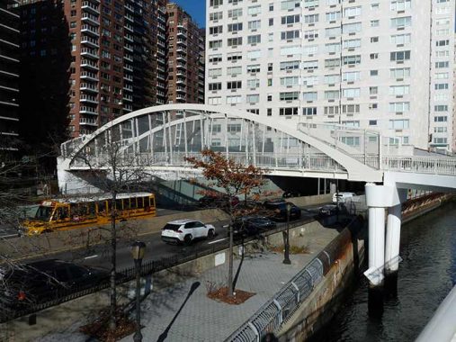
At East 54th Street, a new arch bridge connects Clara Coffey Park to the walkway. In the post-millennial generation of bridges, cable stays and arches are the favored forms. When this bridge was proposed in 2018, neighborhood civic groups opposed the bridge, arguing that it compromised the park.
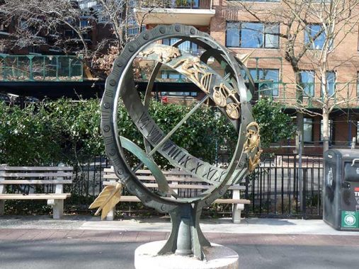
The park’s namesake, Clara Stimson Coffey, worked as a landscape architect at NYC Parks. Her portfolio includes plantings along the Hutchinson River and Belt Parkways, the redesign of the Park Avenue medians, Haffen Park in the Bronx and Yellowstone Park in Queens. The centerpiece of this block-long park is the 1971 sculpture titled Armillary Sphere by Albert Stewart, inspired by Renaissance examples of the astronomical models once used in ancient Greece. Kevin first wrote about it in 2019.
[Don’t even think about using “armillary” in the New York Times Spelling Bee game. –Ed.]
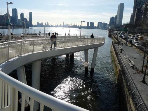
Upon crossing the FDR Drive, the bridge curves down to the walkway. The new walkway does not connect to the waterfront promenade beneath that is accessible by a footbridge at East 51st Street. Looking south towards the UN headquarters, the walkway ends in a stub reminiscent of an unfinished highway or subway line, with the expectation that it will be extended further in the future.
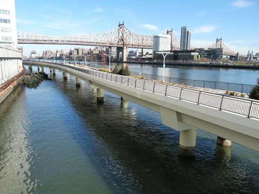
Looking north, the walkway is high enough that future generations of parkgoers don’t need to worry about the impact of sea level rise on this park. The section of Midtown facing the East River is Sutton Place, named for Effingham B. Sutton, a prospector who struck gold in California and developed properties atop the cliffs in the East Fifties into residences.
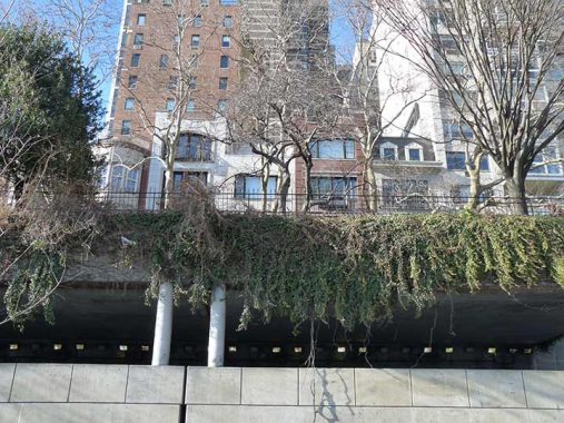
When the FDR Drive was built, some of the buildings here lost access to the waterfront. Robert Moses compensated them by hiding the highway under apartment buildings, parks, and private open spaces. Looking up at the block between 58th and 59th streets, we see Riverview Terrace, a private dead-end overlooking the walkway and East River. The highway runs underneath this road. Former residents here include Jack Warner of the Warner Brothers.
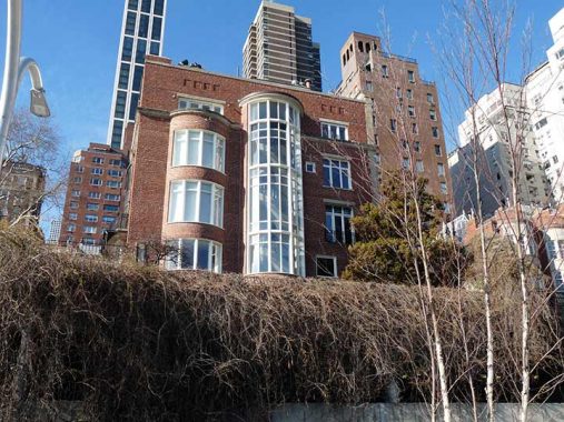
The townhouse at 16 Sutton Square has a spiral staircase popping out of the building that offers views of East River and the Greenway. Built in 1899, its former residents include Aristotle Onassis and John C. Whitehead.
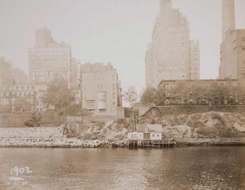
A view of this block from 1934 shows a boat club at the foot of 58th Street that would be obliterated by the highway within a decade. Most of these walk-ups were later replaced with high-rises, with the exception of Riverview Terrace on the left.
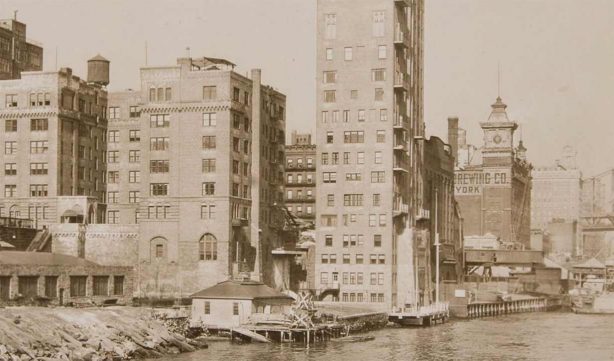
A view taken in 1929 shows Sutton Place as a mixed neighborhood of breweries, tenements, and upscale apartments. The elaborate corner tower seen here is Consumers Brewing Company which had a bottling plant here. The density here appears to push into the East River, demanding the expansion of land to satisfy the city’s growth.
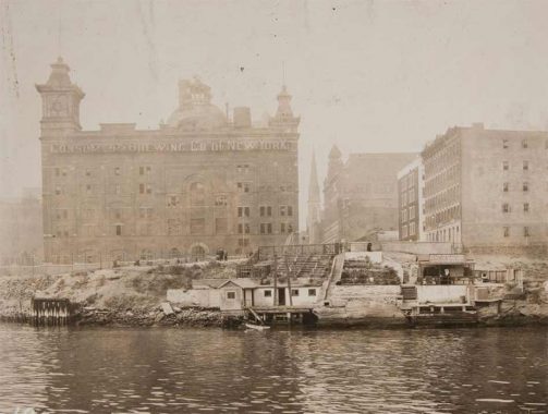
Once lined with beer manufacturers, the East Side’s row of breweries went into decline during Prohibition. Consumers Brewing on East 57th Street closed in 1928 after eight years of making do with non-alcoholic products. Had this building survived past 1965, it would have been a candidate for landmarking with its dome and corner towers.
Also noteworthy in this photo is the Allen Point station of the U.S. Volunteer Life Saving Corps and the spectator benches to its right. I’ve written previously on many of the city’s named points, such as Breezy Point, Crooke’s Point, and Lawrence Point. This is my first time learning about Allen Point. Who was Allen? Did he save any lives? Like other docks on the shoreline, this “volunteer life saving” shack was razed when the FDR Drive was built.
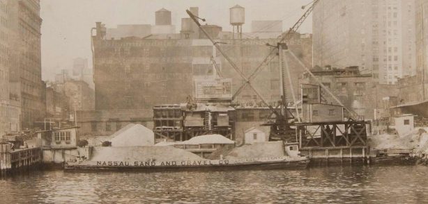
Between 52nd and 53rd streets in 1934, a barge from the Nassau Sand and Gravel Company unloads its freight. Many of Manhattan’s buildings and streets were built using sand mined in Port Washington and brought by boat to docks on the East River.
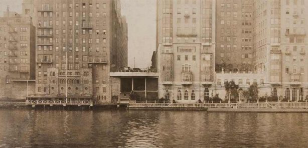
At East 52nd Street was The River Club and Mayfair Yacht Club, private docks with a design inspired by Venice that was removed in favor of the highway. Behind it stands The Campanile, a co-op whose past residents include Greta Garbo, Ethel Barrymore, and Sir Rex Harrison. This building set the trend for Sutton Place’s transformation from the haunt of the Dead End Kids to the neighborhood of celebrities and diplomats.
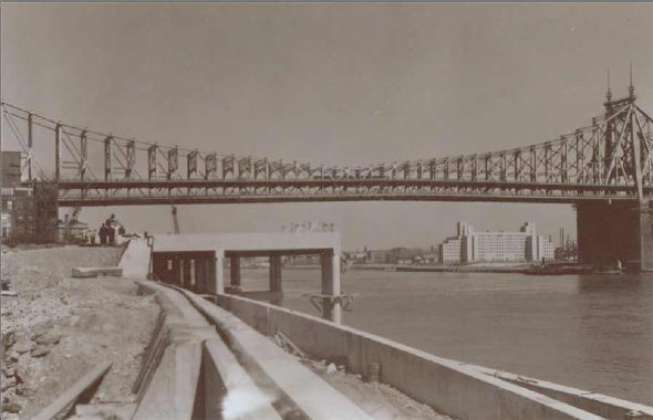
Looking at a photo of the highway’s construction in 1940 from the Municipal Archives we see the unobstructed river views preserved for the residents of Sutton Place in a manner resembling the Brooklyn-Queens Expressway in Brooklyn Heights. Initially named East River Drive, it was renamed for the 32nd president in 1945 after his death. The Sutton Place Underpass appears in Kevin’s detailed 2022 essay on all of the city’s named underpasses.
FDR Drive opened in 1941, notably bypassing the waterfront residences along Sutton Place and running beneath Carl Schurz Park. While Robert Moses famously razed working-class neighborhoods in favor of highways, in wealthy areas he routed them underneath and around buildings using tunnels and land reclamation.
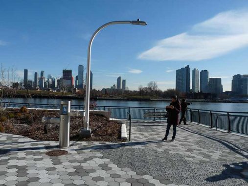
In his lifelong goal to document every type of city lamppost, Kevin found new specimens on the East Midtown Greenway. This one at its southern tip resembles a davit carrying a lifeboat.
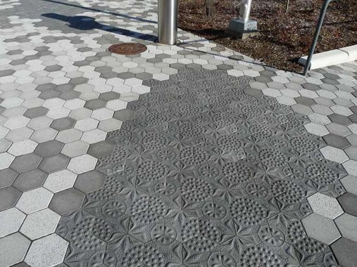
This city has public art everywhere, and here it appears under your feet in embossed concrete pavers titled Diatom Lace by Stacy Levy. The namesake is a microscopic phytoplankton species that floats in the East River where it supplies oxygen to higher life forms on the food chain.
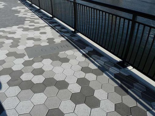
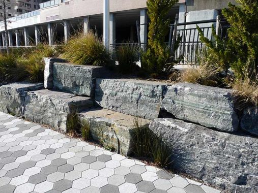
From a distance, the walkway appears as a ramp above the water but as a park it has historic elements and natural materials such as these boulders that resemble the seawall that forms Manhattan’s shoreline.
[Here the city continues the tradition of hexagonal park pavers, but these are flatter and more easily walked-on than those placed in 20th Century parks. — Ed.]
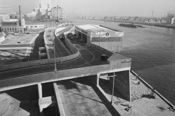
At East 60th Street, the city built a sanitation garage that functioned until 1985. Looking at the turbulent current in the East River, it is difficult to imagine barges docking here to pick up trash. On its facade was an image of a windmill in a nod to the city’s Dutch history.
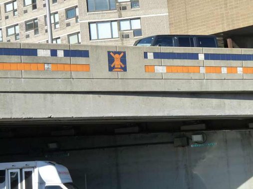
The highway ramps next to this structure also have these windmill mosaics and the blue-white-orange tricolor that was the Dutch flag in the 1600s. The present state flag is a blue field with the state emblem. There is a movement to update the flag with history in mind by incorporating the tricolor and windmill. In 2023, Utah and Minnesota adopted new flags, discarding the old emblem on a color.
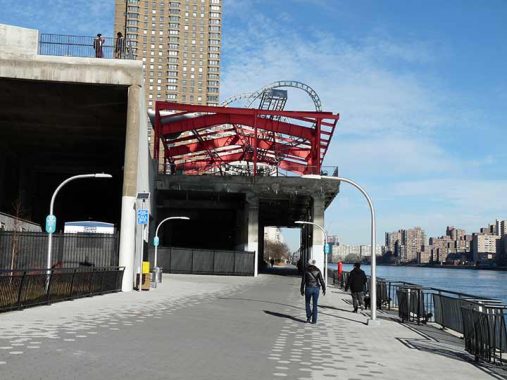
The roof frame of the sanitation shed was preserved and repurposed as the base for Alice Aycock’s sculpture East River Roundabout which was inspired by roller coasters. In a location where the high-rises, Queensboro Bridge, and Roosevelt Island Tramway compete for visual attention, Aycock’s sculpture commands its own audience.
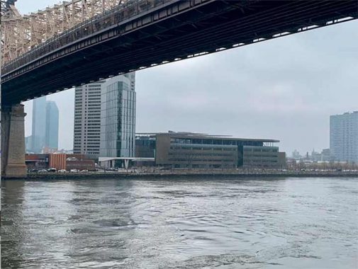
Across the West Channel of the East River is Roosevelt Island, where the bridge’s command of the skyline was partially eclipsed by the Cornell Tech campus. Before this Generation Z institution was built, Coler-Goldwater Hospital stood on this site, treating polio patients before the vaccine became near-universal. Following its closing in 2013, Charles Giraudet gave the Art Deco buildings a respectable eulogy with a photo essay titled Autopsy of a Hospital.
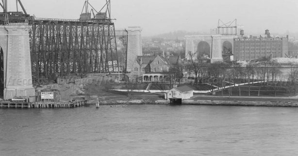
Prior to Coler-Goldwater’s opening in 1939, the southern tip contained a prison, asylum and the Gothic-revival Smallpox Hospital. Matching James Renwick’s landmark, the island had an administrative residence in the same architectural style with an attractive dock that looked like a house above an inlet. Here is how it appeared in 1905 during the construction of Queensboro Bridge. This building too could have been a candidate for landmarking, had it survived to 1965. This building appears in the 1913 painting of the bridge by Edward Hopper. On the Queens side of the East River stood the terra cotta works factory, of which one small building remains today.
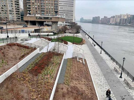
To the north of the Alice Aycock Pavilion is a set of steps that were built in tandem with the greenway, They occupy the site of the 60th Street Heliport, which functioned between 1968 and 1998, handling many flights relating to the nearby hospitals. Those destinations called for it to be shut on account of excessive noise. Shortly before its final takeoff, actor Tommy Lee Jones landed here in the filming of U.S. Marshals. In 2010, the site was named for Andrew Haswell Green, the civic leader who championed the expansion of New York City in 1898.
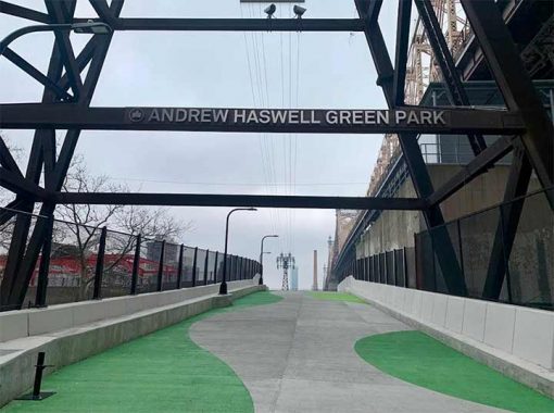
A ramp connecting to 60th Street led to the waste transfer station and heliport. After being designed as a park, the ramp was closed to traffic. The park’s name appears on the support tower of the Tramway that hangs above the ramp.
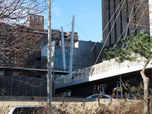
On his visit to the East Midtown Greenway, Kevin exited the park using the 63rd Street footbridge, a cable-stay bridge that is the only one in the city that is crossed by another cable-stayed bridge, one which connects two of Rockefeller University’s buildings. Kevin first crossed that bridge in 2012 and I later noted that this campus stands on the site of Jones Wood, the long-forgotten early alternative to Central Park.
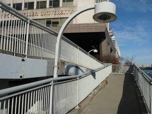
Kevin’s walk on the greenway began and ended with post-millennial bridges and rare light fixture species. On the 63rd Street footbridge the lights appear as a descendant of the sodium luminaires of an earlier generation.
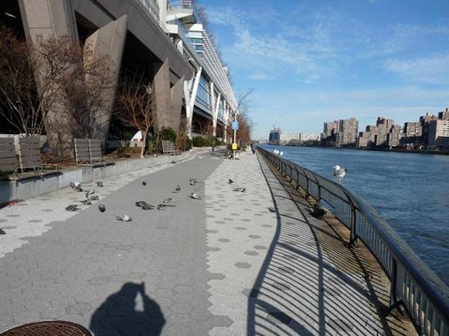
North of the 63rd Street footbridge, the East River Esplanade continues past the row of hospitals built above FDR Drive, with connections to Manhattan’s interior at 68th, 71st, 78th and 81st Streets.
Having honored Clara Coffey and Andrew Haswell Green, there’s one individual who has yet to appear on the map, whose annual Great Saunter around Manhattan’s shoreline led to the creation of this Greenway. As much as I prefer functional names like Queensboro or Triboro, for the East Midtown Greenway, Cy Adler would be the ideal renaming honoree.
You can learn more about this section of the East River shoreline by visiting each of the hyperlinks posted in the essay above.
Sergey Kadinsky is the author of Hidden Waters of New York City: A History and Guide to 101 Forgotten Lakes, Ponds, Creeks, and Streams in the Five Boroughs (2016, Countryman Press), adjunct history professor at Touro University and the webmaster of Hidden Waters Blog.
As always, “comment…as you see fit.” I earn a small payment when you click on any ad on the site. Take a look at the new JOBS link in the red toolbar at the top of the page on the desktop version, as I also get a small payment when you view a job via that link.
12/30/2023

5 comments
Some of the blue and orange tiles have fallen off the FDR so the cars below must
have to dodge them
I will admit I barely notice a lot of this despite seeing them every time I go on the FDR Drive.
Nice tour of the East River Greenway. I used to work in the area, and initially spent my lunchtimes trudging along the stretch just north of the 59th Street Bridge. The only problem was its much-too-close proximity to the noisy FDR Drive. Not very peaceful at all. After a few months, I started spending my lunch breaks in Central Park instead. It was a further walk from my workplace, but far more relaxing.
Another good article Sergey and all the links are very interesting.
Isn’t the FDR the one highway Robert Moses had little to do with? (Only the Triborough approaches)